arroyo lighthouse

Arroyo, Puerto Rico

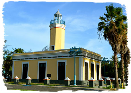
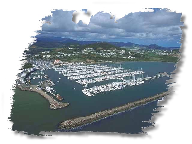
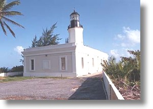
Arroyo, Puerto Rico The Pleasing Town Arroyo (ah-RO-yo) is known as the “Pueblo ingrato” (The ungrateful town), el Pueblo grato (The pleasant town), and “Los bucaneros” (Buccaneers). Its patron is Virgin of Our Lady of Carmen. Arroyo is located on the south of the island. It borders with the municipality of Patillas on the north; the Caribbean Sea to the south; to the west with Guayama and to the east with the municipality of Patillas. Geographically, it belongs to the Ponce-Patillas alluvial plain subregion in the region known as the southern coastal plain. It is a very arid area, although its alluvial plains are very productive because of their...

Casa Alcaldia

Caguas, Puerto Rico

Caguas, Puerto Rico City of the Turabo Caguas (KAH-gwahs) is known as the “City of the Turabo” because it is spread out along the Turabo River valley. The city is also known as “the criollo city” or “the heart of Boriquén”. The festivities are celebrated near December 24 in honor of the Sweet Name of Jesus. The municipality is located in the central eastern part of the island in the geographical subregion called the Caguas or the Turabo River valley. It is bordered on the north by San Juan and Trujillo Alto; on the south by Cayey and San Lorenzo; on the east by Gurabo and San Lorenzo; and...

canovanas alcaldia

Canóvanas, Puerto Rico

Canóvanas, Puerto Rico Valiant Town Canóvanas (kah-NO-vah-nahs) is known as the “brave town” an allusion to the feat of the cacique Yuira who lost her own life defending Spaniards against the tainos. It is also known as the “race town” where Camarero horse-racing track, Puerto Rico’s only racetrack, is located, and “the town of the Chupacabras”. The patron of the municipality is Our Lady of the Pillar. Canóvanas is located on the northeast area of Puerto Rico and is bordered on the north by Loíza, on the south by Juncos and Las Piedras, on the east by Río Grande and Loíza, and on the west by Carolina and Gurabo....

carolina aeropuerto

Carolina, Puerto Rico

Carolina, Puerto Rico Land of Giants Carolina (kah-ro-LEE-nah) is known as the “Land of Giants” and the town of the “arm choppers.” The “Land of Giants” comes from a carolinense named Felipe Birriel Fernández, who was called “the Carolina Giant,” because he was seven feet and eleven inches tall. The latter phrase comes from an old custom of solving disputes in a machete duel. Carolina is the fourth largest city on the island. The patron saint is Saint Ferdinand of the Carolinas. Carolina is on the northeast coast of the island, bordered by the Atlantic Ocean and the town of Loíza to the north, Gurabo and Juncos on the...

ceiba arbol

Ceiba, Puerto Rico

Ceiba, Puerto Rico Soup Eaters Ceiba (sai-EE-bah) and its residents are known as “soup eaters” and the “Marlins” and the town is known as the “Marlin City.” The patron saint is San Antonio de Padua. Ceiba is bordered on the north by the municipality of Fajardo, on the east by the Atlantic Ocean, on the south by the Caribbean Sea and on the west by the municipality of Naguabo. Topographically, Ceiba is part of the region known as the eastern coastal valleys. Its soil, mostly alluvial, was formed by the materials washed down from the mountains by water. It has fertile land on the plains and stony soil in...

culebra carey

Culebra, Puerto Rico

Culebra, Puerto Rico Little Island Culebra (koo-LAI-brah) is an island municipality located to the east of Puerto Rico and separated from the main island by the Vieques Passage. It was earlier known as San Ildefonso and as “the Passage Island.” The island is referred to as “where the sun rises on Puerto Rico”, “the little island”, “the last of the Virgins,” and “the island town”. The patron is Our Lady of Mount Carmel, whose festival is held on July 16. Other important events include tournaments, sports events, and crafts festivals in August, September, and November. There is a small airport on the island and there are several flights and...

fajardo marina

Fajardo, Puerto Rico

Fajardo, Puerto Rico The Hard Faces Fajardo (fah-HAHR-do) is known as the “Town of the Tough Faces,” because of how the residents fought off enemies during Spanish colonial times. Due to its location, it is also known as “The City of the Rising Sun” since it is the town on the main island of Puerto Rico where the sun first rises. The town is the transportation center between the main island of Puerto Rico and the island municipalities of Culebra and Vieques. Fajardo is located on the far eastern tip, east coast of Puerto Rico. It is bordered by the Atlantic Ocean on the north and the east, by...

gurabo

Gurabo, Puerto Rico

Gurabo, Puerto Rico Town of Stairways Gurabo (goo-RAH-bo) is known as the “town of the staircases”, because of the extensive and colorful stairways located in the town. The nickname for residents is “gurabeños”. The municipality of Gurabo is located in the east-central part of Puerto Rico. It is bordered by Trujillo Alto on the north, San Lorenzo on the south, Carolina and Juncos on the east and Caguas on the west. It is part of three distinct geographic regions. The southern portion is part of the eastern mountainous zone. The northern part is within the humid foothills of the north, and central area is part of the Caguas Valley....

Humacao, Puerto Rico

Humacao, Puerto Rico Pearl of The Oriente Humacao (oo-mah-KOU) is known as “the Pearl of the East,” “the gray city,” and “the bone-gnawers”. The patron saint is Our Lady of Immaculate Conception and the Catholic church is dedicated to the Sweet Name of Jesus. Humacao is located on the east coast of Puerto Rico and is part of the eastern coastal valleys. It is bordered by the municipalities of Naguabo on the north, Yabucoa on the south, and Las Piedras on the west, and to the east by the Vieques Passage. Agricultural production is high because of Humacao’s alluvial soil. The lowlands are located near the coast and are...

juncos alcaldia

Juncos, Puerto Rico

Juncos, Puerto Rico Valenciano City Juncos (HOON-kos) is known as the “Valencian City” and its residents are known as the “Valencian Mules.” The patron saint is the Virgin of the Immaculate Conception. Juncos is bordered on the north by the municipality of Carolina, on the east by Las Piedras, on the south by San Lorenzo and Las Piedras and on the west by San Lorenzo. It is located in the southeastern part of the island. Geographically, it is part of the Cayey Range region. In the north are the lower elevations of the Luquillo Range. Today, manufacturing is the main economic activity in the municipality. Juncos has factories producing...

las piedras

Las Piedras, Puerto Rico

Las Piedras, Puerto Rico Artesian City Las Piedras (lahs pee-AI-drahs) is known as the “City of Artisan” and its residents are called pedreños or pedrenses. The Virgin of the Immaculate Conception is the patron saint. Las Piedras is the site of the origin of the Humacao River. It is bordered on the north by the municipality of Río Grande, on the east by Naguabo and Humacao, on the west by Juncos and San Lorenzo, and on the south by the municipality of Yabucoa. Geographically, it is part of the Cayey Range region. In the north are ridges that are part of the Luquillo Range. The name Las Piedras refers...

loiza vejigantes

Loíza, Puerto Rico

Loíza, Puerto Rico Capital of Tradition Loíza (loo-EE-zah) is known as the “The Capital of Tradition,” “The santeros” and “The coconut producers.” The patron saint is Saint Patrick, but the festivities in honor of the patron saint are dedicated to Saint James the Apostle. The festival is one of its principal attractions, especially because of the colorfully dressed vejigantes. Loíza is located on the northeast coast of Puerto Rico. Is bordered on the north by the Atlantic Ocean, on the south by the municipality of Canóvanas, on the east by Río Grande and on the west by the town of Carolina. Loíza is one of the few places in...

luquillo playa

Luquillo, Puerto Rico

Luquillo, Puerto Rico Sun Capital Luquillo (loo-KEE-yo) is known as the “City of Eternal Summer”, the “Sunshine Capital” and the “Puerto Rico Riviera”. The nicknames for residents are “the tourists” and “the coconut eaters”. Luquillo is located in the northeast of the island. It is bordered on the north by the Atlantic Ocean, on the south and the east by Fajardo and on the west by Río Grande. It covers 67 square kilometers (26 square miles) in area. The municipality is part of the northern coastal plains region. It is a very fertile alluvial plain. Although the majority of the territory is flat, there are some lower elevation mountains...

maunabo faro

Maunabo, Puerto Rico

Maunabo, Puerto Rico The Calm City Maunabo (mou-NAH-bo) is known as the “land crab town”, “the town of the land crab eaters”, and “the calm city”. The patron saint is Saint Isidore the Farmer, whose festival is celebrated on May 15. Maunabo is located on the southeast coast, southeast corner of Puerto Rico. It is bordered on the north and northeast by Yabucoa, on the southeast by Patillas, and on the east south east by the Caribbean Sea. There are three regions in the municipality: the Maunabo valley in the south central area, the semiarid hills to the south, and the mountainous region to the east. The town is...

naguabo plaza

Naguabo, Puerto Rico

Naguabo, Puerto Rico Birthplace of Great Artists Naguabo (nah-GWAH-bo) is known as the “Birthplace of Great Artists”, “land crab town”, “the town of the land crab eaters”, and “the quiet town”. The patron saint`s festival is held in honor of Our Lady of the Rosary around October 7 of each year. Homage is also given to Our Lady of Mount Carmel, the patroness of fishermen, on July 17, on the coasts of Naguabo. Naguabo is located on the east coast and east coast of Puerto Rico. It is bordered on the north by Río Grande and Ceiba, by Humacao and the Vieques passage on the south, Ceiba and the...

patillas charco azul

Patillas, Puerto Rico

Patillas, Puerto Rico Emerald of the South Patillas (pah-TEE-yahs) is known as “The Emerald of the South” and “the Melons”. The patron saint is Holy Christ the Healer and the saint’s festival is held in August. Attractions of the town include beaches, forests, and Patillas Lake. The coastal waters and the lake are used by many for recreational fishing. Patillas is located on the southeast coast of the island. It is bordered on the north by Cayey and San Lorenzo and the south by the Caribbean Sea, on the east by Yabucoa and Maunabo, on the west by Arroyo, and on the northeast by Guayama. Although a significant part...

riogrande yunque

Río Grande, Puerto Rico

Río Grande, Puerto Rico El Yunque City Río Grande (REE-o GRAHN-de) is known as the “City of El Yunque”. The mountainous zone is part of the Caribbean National Forest, which is part of the Luquillo mountain range. The majority of this forest is located within the municipality of Río Grande. The municipality’s patron saint is the Virgen de Nuestra Señora del Carmen. Río Grande is bordered on the north by the Atlantic Ocean, on the east by the municipalities of Luquillo and Ceiba, on the west by Loíza, and on the south by Naguabo and Las Piedras. Geographically, it is part of the region called the northern coastal plains....

sanlorenzo chayanne

San Lorenzo, Puerto Rico

San Lorenzo, Puerto Rico The Town of the Samaritans San Lorenzo (san lo-REN-zo) is known as the “Town of Samaritans” and the “Samaritan City”. The patron saints of the town are Nuestra Señora de las Mercedes and San Lorenzo, for whom the town is named. San Lorenzo is located in the eastern part of Puerto Rico. It is bordered on the north by the municipality of Gurabo, on the east by Juncos and Las Piedras, on the west by Caguas and on the south by Patillas and Yabucoa. This municipality is part of the geographic region called the Caguas interior valley, although in the southeast part there are some...

trujilloalto represa

Trujillo Alto, Puerto Rico

Trujillo Alto, Puerto Rico Laid Back Town Trujillo Alto (troo-HEE-yo AHL-to) is known as the “City of Springs,” the “Town of Eight Streets,” the “City in the Country” and the “Town of Learners”. The municipality of Trujillo Alto is located in the northern part of Puerto Rico. It is bordered by San Juan on the north and west, by Caguas and Gurabo on the south and by Carolina on the east. It is part of the northern coastal plain and the karst zone. The vegetation is typical of tropical humid forests. Trujillo Alto is mostly hilly and the region is humid. Previously, the municipality’s lands were dedicated mainly to...

vieques sunbay

Vieques, Puerto Rico

Vieques, Puerto Rico Baby Island Vieques (vee-AI-kais), baptized the “Baby Island”, or “Little Girl Island”, by poet Luis Llorens Torres, is located 10 kilometers (6 miles) southeast of Puerto Rico. The patron saint festival is held in July in honor of the Virgen del Carmen, the patron saint of Vieques. Vieques is currently in the process of reorienting its economy due to the transfer of lands formerly occupied by the United States Navy to the government of Puerto Rico in May of 2003. The eastern part of the island is now under the control of the United States Fish and Wildlife Service while various parts of the western zone...

Yabucoa, Puerto Rico

Yabucoa, Puerto Rico City of Sugar Yabucoa (yah-boo-KO-ah) is known as the “City of Sugar,” “Town of the Yuca,” and its residents, Yabucoeños, are nicknamed “milky drinkers”. The name Yabucoa comes from the Taino chief Guaroca, which means “place or site with water”, according to some scholars. Others say the name refers to “place of cassava”. Yabucoa is located in the southeast of Puerto Rico. It is bordered on the north by San Lorenzo, Las Piedras and Humacao, on the west by San Lorenzo and Patillas, on the south by Maunabo and the Caribbean Sea; and on the east by the Caribbean Sea. Geographically, it is part of the...

You May Also Like