Gurabo, Puerto Rico
Town of Stairways
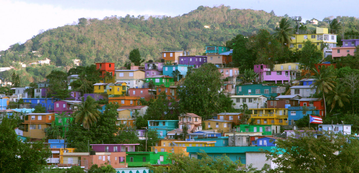
 Gurabo (goo-RAH-bo) is known as the “Town of the Stairs” due to its iconic colorful staircases that adorn the town center, making them a symbol of the municipality. Its residents are called gurabeños, and they maintain a strong sense of cultural and heritage identity.
The municipality of Gurabo is located in the central-eastern region of Puerto Rico. It borders Trujillo Alto to the north, San Lorenzo to the south, Carolina and Juncos to the east, and Caguas to the west, separated from Caguas by the Río Grande de Loíza. This strategic location has allowed Gurabo to function as an important link between the San Juan metropolitan area and the southeastern municipalities of the island.
Gurabo spans three distinct geographical regions:
- Southern zone: Mountainous, part of the eastern mountain region.
- Northern zone: Corresponds to the northern humid hills.
- Central zone: Part of the Caguas Valley, the largest of Puerto Rico’s interior valleys. This valley was formed through the erosion of the Río Gurabo, Río Grande de Loíza, and Río Valenciano. Its extremely fertile soils have historically supported agriculture.
Economy
Gurabo’s economic activity has evolved over time:
- Manufacturing remains predominant, producing metal, paper, plastics, chemicals, pharmaceuticals, textiles, machinery, and electrical equipment.
- Agriculture and livestock also form part of the economy, with the cultivation of minor fruits and tobacco. Some sugarcane crops are still maintained, reflecting the crop’s historical importance to the municipality’s economy.
Growth and Urbanization
Gurabo has become one of the fastest-growing municipalities in recent decades, establishing itself as a satellite suburb of the San Juan metropolitan area. A significant portion of its residents work in the capital, which has driven residential construction and improvements in road infrastructure and public services. Additionally, the proximity to urban centers has fostered commercial and service expansion within the municipality.
Foundation and History
Before becoming an independent municipality, Gurabo was a barrio of Caguas called Burabo. Due to its distance from the main town, residents faced transportation challenges and limited access to essential services, especially during the 18th century.
In 1812, the 168 heads of households living in the barrio met to find solutions to these issues. They decided to declare themselves independent from the judicial, ecclesiastical, and medical authorities of Caguas, arguing that the population of the barrio deserved better economic and social attention.
Don Luis del Carmen Echevarría was granted the authority to manage the foundation of the new town, which was officially established in 1815. Later, in 1822, Gurabo erected its own canonical parish, dedicated to Patriarch Saint Joseph (San José), solidifying both the religious and civic identity of the community.
Location
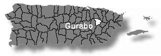 Gurabo is located in the central-eastern region of Puerto Rico. It is bordered to the north by Trujillo Alto, to the south by San Lorenzo, to the east by Carolina and Juncos, and to the west by Caguas, from which it is separated by the Río Grande de Loíza.
This strategic location has made Gurabo an important link between the San Juan metropolitan area and the municipalities in the southeastern part of the island.
Area
73.24 km² (28.28 mi²)
Population
40,622 (2020 Census)
Population Density
503.3 people/km² (1,312 people/mi²)
Demonym
Gurabeños
Nicknames
- The Town of the Stairs — referring to its famous colorful staircases.
- Gateway to Southeast Tourism — highlighting its strategic location and role as a portal to southeastern Puerto Rico.
Barrios of Gurabo
Gurabo is organized into ten barrios, including both urban and rural areas. This structure allows for efficient municipal administration and public service planning, reflecting the municipality’s cultural and geographic diversity.
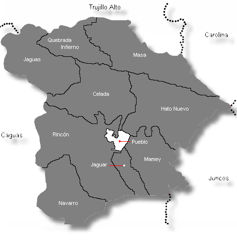
| Census 2020: Population by Barrios - Gurabo |
Population |
| Celada | 2,748 |
| Gurabo Pueblo | 1,213 |
| Hato Nuevo | 8,607 |
| Jaguar | 1,166 |
| Jaguas | 2,300 |
| Mamey | 4,270 |
| Masa | 852 |
| Navarro | 10,157 |
| Quebrada Infierno | 403 |
| Rincón | 9,092 |
| Total | 40,622 |
Source: Censo 2000
Patron Saint
Patron: Saint Joseph (San José)
Parish: San José
Address: P.O. Box 733, Gurabo, Puerto Rico 00778
Phone: (787) 737‑2656
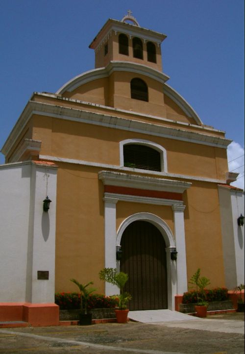
The San José Parish is the religious center of Gurabo and serves as the focal point for patronal festivities and community events throughout the year.
Topography
Gurabo is part of the Caguas Valley, the largest valley in the interior of Puerto Rico, known for its fertile soils that have historically supported agriculture.
- Northern Region: Features the Cuchilla de Hato Nuevo, with the highest point within Gurabo being Cerro La Silla in the Masa barrio, reaching 367 meters (1,204 feet) above sea level.
- Southeastern Region: The Mamey barrio contains smaller elevations corresponding to the Sierra de Cayey, contributing to the municipality’s varied mountainous landscape.
This topographical diversity affects the local climate, agricultural practices, and the distribution of communities across Gurabo.
Hydrography
- Major River: Río Grande de Loíza, which forms the boundary with Caguas.
- Primary Tributary: Río Gurabo.
Other Streams and Waterways:
- Quebrada Grande
- Quebrada Infierno
- Quebrada Maracuta
These rivers and streams have been vital for agricultural development and for sustaining local ecosystems.
Climate
Gurabo has a tropical humid climate, typical of the central-eastern region of Puerto Rico. Temperatures are generally mild throughout the year:
- Average high: 87.0 °F (30.5 °C)
- Average low: 65.5 °F (18.6 °C)
- Annual rainfall: 63.35 inches (1,610 mm)
These conditions favor local agriculture, help preserve rivers and streams, and contribute to the municipality’s natural beauty. Seasonal variations influence outdoor activities and cultural events celebrated throughout the year.
Predominant Industries
The economy of Gurabo is a mix of manufacturing and agriculture, which has evolved over time:
- Manufacturing: Metal, paper, plastics, chemicals, pharmaceuticals, textiles, machinery, and electrical/electronic equipment.
- Agriculture and Livestock: Cultivation of small fruits, tobacco, and other traditional crops. Livestock farming contributes to the local food supply.
- Historical Note: Gurabo was also historically known for sugarcane production, which played a significant role in its past economy.
This combination of industries supports local employment, strengthens ties with the San Juan metropolitan area, and sustains the municipality’s economic balance.
Flag
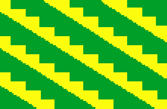 The flag of Gurabo consists of eleven alternating stripes, six green and five yellow. The yellow stripes feature a stepped upper edge resembling a staircase, with each step measuring two units high by three units wide.
- Colors and Symbolism: The green and gold colors reflect the primary colors of the municipal coat of arms, with gold representing metal and agriculture.
- Design Significance: The staircase pattern alludes to the five iconic staircases in Gurabo, giving rise to the nickname “Pueblo de las Escaleras” (Town of the Stairs).
Coat of Arms
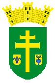 The coat of arms of Gurabo is rich in symbolism:
- Field: Green (sinople) background with a broad golden patriarchal cross.
- Escutcheons:
Right escutcheon: Blue fleur-de-lis, representing the founder, Don Luis del Carmen Echevarría.
Left escutcheon: Blue vase from Zaira, Extremadura, Spain (founder’s birthplace), from which grow three natural lilies. - Crown: Golden mural crown with three towers, as per Puerto Rican municipal heraldry.
Symbolism
- The patriarchal cross honors Saint Joseph, patron of Gurabo.
- The escutcheons connect the town to the founder’s personal history and Spanish origin.
- The mural crown denotes Gurabo’s status as a town.
Together, the flag and coat of arms reflect Gurabo’s historical, cultural, and religious identity, linking the founder, the patron saint, and the municipality’s urban heritage.
Points of Interest
Gurabo offers various places that showcase its history, culture, and natural beauty, ideal for recreation, tourism, and learning:
- Gurabo Exhibition Center: Features local crafts, artwork, and cultural projects from the municipality.
- El Cerro: Scenic viewpoint offering panoramic views of the Caguas Valley and surrounding mountains.
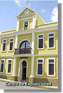
- Old Town Hall (La Antigua Casa Alcaldía): Historic building that preserves its original clock and represents the town’s administrative history.
- Parish of San José: Main church and center for patronal festivities and religious events.
- Luis Muñoz Marín Recreational Plaza: Public space for cultural activities, recreation, and community gatherings.
- Hacienda Mirador: Historic agricultural estate offering educational experiences about Gurabo’s farming heritage.
- Loíza Lagoon: Natural area that supports ecological conservation and recreational activities.
- Turabo University Museum: Exhibitions of arts and culture, with educational programs open to the public.
- Parque Cofresí: Recreational park with sports facilities and leisure areas for families.
Events
Gurabo celebrates numerous festivities and cultural events throughout the year:
- Patronal Festival in honor of San José – March: Religious and cultural celebration in the town center with music, food, and traditional activities.
- Festival of the Home Garden – May: Promotes urban agriculture, environmental education, and local products.
- Youth Festival – May: Cultural and recreational activities for young people, including music, workshops, and sports competitions.
- Mapeyé Festival – October: Dedicated to preserving the traditional Puerto Rican music genre mapeyé.
Additional cultural, artistic, and sporting events take place year-round, strengthening community identity and participation.
Notable People
Gurabo has been the birthplace of many personalities who have contributed to Puerto Rico’s history, culture, politics, and education:
- Luis del Carmen Echevarría (1781–1852): Mayor in 1812, 1823, 1826, and 1833. Founder of Gurabo in 1815, instrumental in establishing the municipality and promoting its early economic and social development.
- José Emilio González (1918–1990): Poet, essayist, journalist, and university professor. Recognized by the Institute of Puerto Rican Culture and the Ateneo Puertorriqueño for his contributions to literature and cultural thought.
- Nilda González Monclova: Librettist, actress, and professor at the University of Puerto Rico, noted for her work in theater and arts education.
- Ángel Celestino Morales: Writer who explored multiple literary genres, including poetry, narrative, and essay, reflecting Puerto Rican identity and traditions.
- Ángel Viera Martínez (1919–2003): Lawyer and politician; founding member of the New Progressive Party (PNP), Representative (1969–1985), and PNP Vice President (1983). Co-founder of the Puerto Rican Renewal Party with Dr. Hernán Padilla.
- Harry Colón Díaz: Environmental advocate recognized for community work in Santa Rita and Masas neighborhoods, promoting ecological conservation and education.
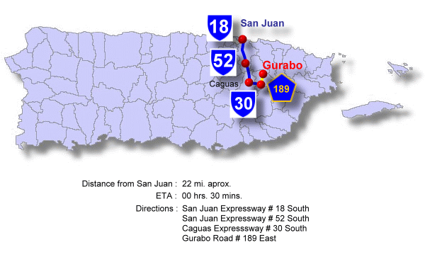
Transportation and Accessibility
Gurabo is well connected via PR‑30, a highway that links the municipality with Caguas and the San Juan metropolitan area, as well as with Juncos and Humacao to the east.
Public transportation includes shared taxis (carros públicos) and intercity buses, facilitating mobility for both residents and visitors.
Education
Gurabo offers public and private schools, as well as institutions of higher education. Among them is the University of Turabo (now Ana G. Méndez University – Gurabo Campus), recognized for its academic programs, research initiatives, and cultural contributions to the municipality and the region.
Public Schools sorted by educational levels.
Humacao Region
Gurabo District
| Name | Level | Telephone | Address |
| Elementary | |||
| CELADA CARRETERA | K-6 | (787) 737-4346 | PO Box 1131, P.R. 00778-0000 |
| HATO NUEVO | K-6 | (787) 737-4347 | PO Box 1335, P.R. 00778-0000 |
| JAGUAS | K-6 | (787) 737-6066 | PO Box 1369, P.R. 00778-0000 |
| LUIS MUÑOZ RIVERA | PK-3 | (787) 737-2216 | PO Box 1364, P.R. 00778-0000 |
| MARGARITA RIVERA DE JANER | 4-6 | (787) 737-6594 | PO Box 879, P.R. 00778-0000 |
| MAXIMINA MÉNDEZ | K-6 | (787) 737-8366 | PO Box 1359, P.R. 00778-0000 |
| VILLA MARINA | K-6 | (787) 737-4344 | PO Box 580, P.R. 00778-0000 |
| Intermediate | |||
| MATÍAS GONZÁLEZ GARCÍA | 7-9 | (787) 737-2056 | PO Box 1346, P.R. 00778-0000 |
| Secondary | |||
| SU JOSEFINA SITIRICHE | K-9 | (787) 737-2626 | PO Box 38, P.R. 00778-0000 |
| SU SANTA RITA | K-9 | (787) 737-6222 | HC 1 BOX 4226, P.R. 00778-0000 |
| SU VIDAL SERRANO | K-9 | (787) 747-2323 | PO Box 1090, P.R. 00778-0000 |
| High School | |||
| DRA. CONCHITA CUEVA | 10-12 | (787) 737-2700 | PO Box 1293, P.R. 00778-0000 |
Hymn:
By Miguel Monserrate
En un valle rodeado por montañas nace un
pueblo de entre el barro.
Con valor fue creado por hombre de fe
y constancia para honrar
y alabar al Creador.
En Gurabo un pueblo con mucho orgullo
de costumbres de cultura y devoción
donde el tiempo se detiene ante el arrullo
de su gente de su historia y tradición.
CORO
Gurabo es mi pueblo, es mi hogar,
es mi vida, es mi orgullo, es mi cantar,
es mi música, es mi sueño, es mi luchar...
mi instrumento de alegría y mi soñar.
Gurabo es mi pueblo, es mi hogar,
escalera al paraíso terrenal
de las voces de su gente surge el himno
que se cantará por toda la eternidad.