Cabo Rojo, Puerto Rico
Cofresí's Town
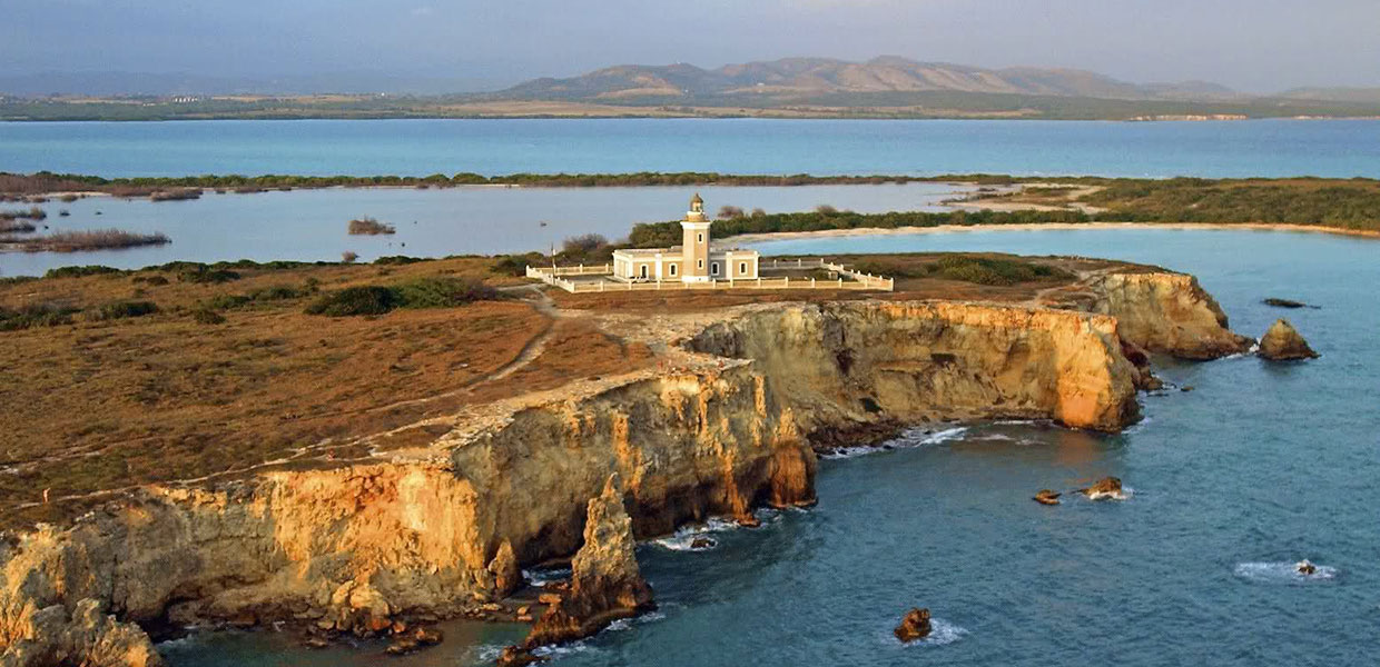
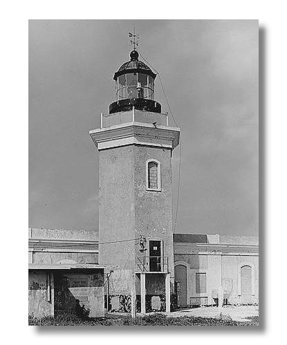 Cabo Rojo (KAH-bo, ro-ho) is known as “the town of Cofresí,” “los mata con hacha,” “the cradle of Betances,” and “the capital of domestic tourism in Puerto Rico.” This municipality stands out for the diversity of its geography, the richness of its natural resources, and the biodiversity of its ecosystems. Among its main attractions are the Faro de Los Morrillos, a historic and tourist symbol rising above the limestone cliffs, and its renowned beaches such as Combate, Boquerón, Playa Sucia, Puerto Angelino, and Joyuda.
Additionally, Cabo Rojo is home to beautiful lagoons such as Atolladero, Joyuda, Guaniquilla, and Caño Boquerón; bays like Bramadero, Puerto Real, Boca Prieta, Boquerón, Salinas, and Sucia; as well as the emblematic salt flats, the Boquerón State Forest, and the Sierra Bermeja. These landscapes make the municipality a privileged vacation destination and a reference point for ecological and scientific research in Puerto Rico.
The Faro de Los Morrillos, built in 1882 and automated in 1967, is one of the most photographed icons on the island. From its lookout, visitors can admire the majesty of the Caribbean Sea, the reddish cliffs of Los Morrillos, and parts of the municipality’s natural reserves, making it a must-visit for tourists and nature enthusiasts.
Cabo Rojo also features the National Wildlife Refuge, marine laboratories in Punta Arenas and El Combate, and the cave of the legendary pirate Roberto Cofresí, where he is said to have hidden his treasures. These attractions, along with tourist centers such as the Boquerón Vacation Center, the Nautical Club, Villa Taína, and Villa Pesquera, establish the municipality as a tourism, economic, and cultural hub in southwestern Puerto Rico.
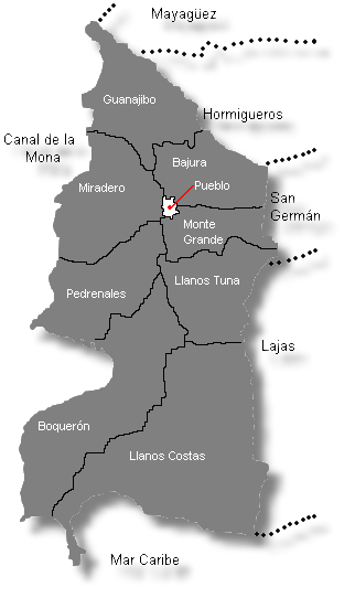
Located at the southwestern tip of the island, Cabo Rojo borders Mayagüez and Hormigueros to the north, the Caribbean Sea to the south, San Germán, Hormigueros, and Lajas to the east, and the Mona Channel to the west, belonging to the subregion of the western coastal valleys.
Foundation:
The name “Cabo Rojo” comes from the companions of Christopher Columbus during his second voyage to the Americas. When the Admiral and his crew attempted to sail around the island, they observed the characteristic reddish tone of the land in the southwest—an area now known as Los Morrillos—and named it “Los Cabos Rojos.”
Long before the arrival of Europeans, these lands were already inhabited. Anthropological studies reveal that the Cabo Rojo coast was occupied from the early centuries of the Christian era by the Siboney indigenous group. Later, the Arawaks established new settlements belonging to the Ostionoide culture, known for cultivating cassava and mastering pottery.
American archaeologist Christopher Goodwin asserts that Punta Ostiones in Cabo Rojo was one of the first commercial exchange centers between the indigenous cultures of Puerto Rico and other Caribbean islands. Today, many modern communities are located on top of these ancient indigenous settlements.
According to Cabo Rojo historian Salvador Brau y Asencio, by the year 1512, there was already a core of inhabitants near Los Morrillos. In 1525, the salt flats of Cabo Rojo represented a highly valuable economic resource, coveted by neighboring towns.
Although the first request to establish Cabo Rojo as a municipality was denied in 1759, the efforts led by Don Nicolás Ramírez de Arellano succeeded in achieving its official foundation in 1771.
Location:
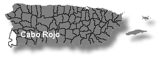 Cabo Rojo is located at the southwestern tip of Puerto Rico. It borders Mayagüez and Hormigueros to the north, the Caribbean Sea to the south, the Mona Channel to the west, and the municipalities of Hormigueros, San Germán, and Lajas to the east.
Area:
182.4 square kilometers (70.4 square miles)
Average Elevation:
35 meters (115 feet) above sea level
Population:
47,158 (2020 Census)
Population Density:
257 inhabitants per square kilometer
Demonym:
Caborrojeño
Nicknames:
The Town of Cofresí
Los Mata con Hacha
Neighborhoods: Cabo Rojo, Puerto Rico
| Census 2020: Population by Wards - Cabo Rojo |
Habitants |
| Bajura | 2,364 |
| Boquerón | 4,963 |
| Cabo Rojo Pueblo | 1,305 |
| Guanajibo | 3,577 |
| Llanos Costa | 3,495 |
| Llanos Tuna | 5,765 |
| Miradero | 14,358 |
| Monte Grande | 6,275 |
| Pedernales | 4,809 |
| Total | 47,158 |
Source: U.S. Census Bureau, 2000 Census
Patron Saint:
San Miguel Arcángel
Parish: San Miguel Arcángel
P.O. Box 625
Cabo Rojo, Puerto Rico 00623
Phone: (787) 851-1283
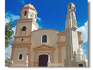
The San Miguel Arcángel Parish, located in front of Plaza Ramón Emeterio Betances, was established in 1783 and is one of the oldest churches in southwestern Puerto Rico. Its current structure has been restored multiple times, preserving its architectural and historical value.
Mass Schedule::
- Monday to Friday: 7:00 a.m. and 5:30 p.m.
- Sunday: 7:00 a.m., 9:00 a.m., 11:00 a.m., and 7:00 p.m.
During the Christmas season, the parish celebrates the traditional Misas de Aguinaldo, an event that brings together families, musicians, and parishioners from across the region.
Topography:
Cabo Rojo is primarily located in the Western Coastal Plain, giving it a mostly flat territory ideal for agriculture and urban development. However, the municipality also features isolated elevations that stand out in its landscape, including:
- Cerro Mariquita: 988 feet (301 m), the highest point in the municipality.
- Cerro Buena Vista: approximately 850 feet (259 m).
- Cerro Vargas: between 623 and 650 feet (190‑198 m).
- Peñones de Melones: 328 feet (100 m).
The Sierra Bermeja, one of the oldest formations in southwestern Puerto Rico, crosses part of the municipality, creating microclimates, natural runoff, and significant biodiversity that distinguishes it from other flat regions of the island.
Hydrography:
The municipality is crossed by several bodies of water that support its ecosystem:
- Guanajibo River, the main river flowing into the sea.
- Arroyo Cajul and Caño Conde Ávila, along with several smaller streams such as Boquerón, La Costa, and Los Chorros, which flow into coastal lagoons and salt flats.
These water bodies contribute to wetland conservation, support local wildlife, and maintain the salt flat systems, which are a significant natural and tourist resource.
Main Industries
Cabo Rojo’s economy combines traditional and modern sectors:
- Tourism and services: The main economic driver, based on beaches, natural reserves, the lighthouse, and gastronomy.
- Artisanal fishing and aquaculture: Supports coastal communities and supplies local restaurants.
- Light manufacturing: Includes textiles, food products, medical equipment, and machinery.
- Agriculture and livestock: Cultivation of watermelon, tomatoes, peppers, sugarcane, and small-scale livestock.
Tourism and fishing stand out as the primary sources of employment, while agriculture maintains its historical relevance in the flat areas of the municipality.
Income and Average Salary
Historically, reported salaries in 1998 were $230.77 per week. Recent data show significant changes:
- According to the 2020 Census, the average per capita income in Cabo Rojo is approximately $9,903, below the state average.
- Manufacturing and tourism services offer variable salaries, slightly below Puerto Rico’s average, although tourism generates much of the seasonal and temporary employment.
These figures highlight the importance of tourism and fishing in the local economy, as well as the need to diversify income sources within the municipality.
Flag
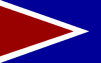 The flag of Cabo Rojo reflects the main symbols of its coat of arms, although it omits certain elements such as the sword, anchors, and mural crown. It was officially approved in 1971 by both the Puerto Rican Institute of Culture and the Cabo Rojo Municipal Assembly.
The creation of the flag is attributed to Mr. Roberto Bíascochea, who sought to preserve the historical and cultural colors and meanings of the municipality, highlighting Cabo Rojo’s identity in its official visual representation. The main colors—blue, red, and white—symbolize the history, geography, and ideals of the people of Cabo Rojo.
Coat of Arms:
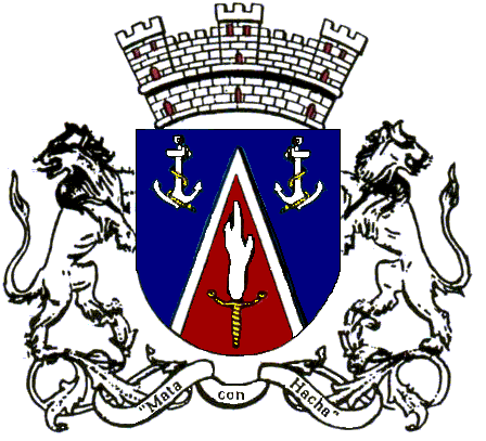 The coat of arms of Cabo Rojo incorporates three main colors: blue, red, and silver, each associated with local historical figures: Don Nicolás Ramírez de Arellano, founder of the town, and Dr. Ramón Emeterio Betances, abolitionist leader and Puerto Rican independence hero.
- The red triangle symbolizes Cabo Bermejo, the rocky formation of Los Morrillos.
- The blue and white, together with the anchors, represent the surrounding sea and the municipality’s maritime importance.
- The flaming sword is an attribute of San Miguel Arcángel, the patron saint of Cabo Rojo.
- The mural crown indicates the municipality status, emphasizing its autonomy and administrative relevance.
The coat of arms reflects both local history and the ideals of freedom and justice promoted by Cabo Rojo’s prominent figures, serving as an emblem of identity and pride for its residents.
Events
Cabo Rojo is distinguished by its cultural and recreational calendar, combining religious traditions, food festivals, and sports competitions:
- Festival de Reyes – January: Traditional celebration with family activities, including parades and cultural performances.
- Festival del Pescao – March: Culinary event highlighting local fishing and Cabo Rojo cuisine.
- Jornada Betances – April: Commemorative activities honoring Ramón Emeterio Betances, highlighting his historical and social legacy.
- Cabo Rojo International Triathlon – Summer: Sports competition attracting national and international athletes.
- Fiestas Patronales de Cabo Rojo – September: Tribute to San Miguel Arcángel, with processions, concerts, and cultural events.
- Christmas Lighting – December: Family celebration with lights, music, and holiday activities in plazas and public spaces.
Places of Interest
- Boquerón State Forest: Protected area with trails and unique biodiversity.
- Cofresí Pirate Cave: Historical pirate legend attracting tourists and researchers.
- San Miguel Arcángel Catholic Church: Historic monument and center of local religious life.
- La Milla de Oro del Buen Comer (Joyuda): Renowned seaside gastronomic area.
- Logia Cuna de Betances: Historic center linked to local heroes.
- Monument to Salvador Brau: Tribute to the Cabo Rojo historian and writer.
- Museum of the Heroes: Exhibits on Puerto Rican historical figures.
- Obelisk: Landmark monument in the central plaza.
- Cabo Rojo National Wildlife Refuge: Center for ecological conservation and sustainable tourism.
- Schoenstatt Sanctuary: Place of spirituality and pilgrimages.
- Rebekah Colberg Sports Coliseum: Facility for local sports and cultural events.
- Faro de los Morrillos: Tourist and historical icon of Cabo Rojo.
- Laguna de Joyuda: Natural area for fishing and birdwatching.
- Cabo Rojo Salt Flats: Historical heritage and internationally important ecological reserve.
- Monument to Ramón Emeterio Betances: Tribute to the abolitionist hero.
- Monument to Roberto Cofresí Ramírez de Arellano: Celebrates the famous pirate from Cabo Rojo.
- New City Hall: Modern administrative center of the municipality.
- Plaza Ramón Emeterio Betances: Public space for cultural and recreational activities.
- Boquerón Wildlife Refuge: Sanctuary for native and migratory species.
- Sierra Bermeja: Area of great biodiversity, ideal for ecotourism and hiking.
Beaches:
- Combate Beach
- Punta Arenas Beach
- Punta Aguila Beach
- La Mela Beach
These beaches combine recreational tourism, artisanal fishing, and environmental conservation opportunities, making them constant attractions for both local and international visitors.
Notable Figures
Cabo Rojo has been the birthplace of prominent figures in politics, history, sports, and culture:
- Ramón Emeterio Betances y Alacán – Physician, abolitionist leader, and Puerto Rican hero.
- Salvador Brau Asencio – Historian, journalist, playwright, and essayist.
- Salvador Carbonell – Physician, politician, and vice-president of the Autonomist Party.
- Elisa Colberg – Educator and highest leader of scouting in Puerto Rico.
- Rebekah Colberg – Pioneer of women’s sports in Puerto Rico.
- Juan Enrique Colberg Petrovich – Writer and poet.
- Severo E. Colberg Ramírez – Notable politician, member of the House of Representatives (1964–1990).
- Emilio del Toro Cuebas – Chief Justice of the Supreme Court, writer, and civic leader.
- Roberto Cofresí y Ramírez de Arellano – Famous pirate from Cabo Rojo.
- Salvador Mestre y Mora – Jurist, politician, autonomist leader, and founder of the newspaper El País.
Public Schools sorted by educational levels.
San Germán Region
Cabo Rojo District
| Name | Level | Telephone | Address |
| Elementary | |||
| CARLOTA MATIENZO | K-6 | (787) 255-3725 | PO Box 1315, P.R. 00623-1315 |
| JAMES GARFIELD | K-6 | (787) 851-5027 | PO Box 770, P.R. 00623-0770 |
| LUIS MUÑIZ SOUFFRONT | K-6 | (787) 851-0884 | PO Box 1326, P.R. 00623-0868 |
| MANUEL FERNÁNDEZ JUNCOS | K-6 | (787) 851-1825 | PO Box 278, P.R. 00622-0278 |
| PEDRO FIDEL COLBERG | K-6 | (787) 851-1168 | PO Box 538, P.R. 00622-0000 |
| RAMON E BETANCES | K-6 | (787) 255-6705 | PO Box 770, P.R. 00623-0000 |
| SEVERO E COLBERG RAMÍREZ | PK-6 | (787) 255-2720 | PO Box 1150, P.R. 00623-0000 |
| Intermediate | |||
| LUIS MUÑOZ MARÍN | 8-9 | (787) 851-1601 | 77 CALLE RIUS RIVERA PUEBLO NUEVO, P.R. 00623-0000 |
| PEDRO NELSON COLBERG | 7-8 | (787) 851-1470 | PO Box 1316, P.R. 00623-1316 |
| Secondary | |||
| SEBASTIÁN PABÓN ALVES (COROZO) | K-9 | (787) 255-2028 | PO Box 1322, P.R. 00623-1322 |
| SU ANTONIO ACARON CORREA | 1-9 | (787) 851-3383 | PO Box 1315, P.R. 00623-1315 |
| SU BARTOLOMÉ JAVIER PETROVITCH | K-9 | (787) 851-3500 | PO Box 1306, P.R. 00623-0000 |
| SU CARMEN VIGNALS ROSARIO | K-9 | (787) 851-3200 | PO Box 868, P.R. 00623-0000 |
| SU FEDERICO DEGETAU | K-9 | (787) 851-1047 | Carr. BOQUERÓN, P.R. 00623-0000 |
| High School | |||
| INÉS MARIA MENDOZA | 10-12 | (787) 851-5037 | PO Box 610, P.R. 00623-0000 |
| MONSERRATE LEÓN IRIZARRY | 10-12 | (787) 254-2288 | PO Box 1235, P.R. 00622-1235 |
Hymn:
By: Mildred Arroyo
Hoy estoy triste por la distancia
que me separa de mi dulce patria,
y de un pueblito donde mi
padre y mi madre me esperan
Mi Cabo Rojo pueblo adorado,
jardín de flores te quiero yo
y en la distancia a ti te añoro,
por eso lloro en mi cantar.
Son tus palmeras flores divinas
y son tus playas, un manantial
Mi Cabo Rojo, me siento solo
por eso lloro en mi cantar
pero muy pronto besaré tu suelo
o desde el cielo te adoraré.