Manatí, Puerto Rico
Metropolitan City · The Athens of Puerto Rico
Manatí (mah-nah-TEE) is known as the Metropolitan City and as “The Athens of Puerto Rico,” a nickname that emerged from its notable cultural and intellectual development during the early decades of the twentieth century. This recognition reflects the municipality’s role as a center of literary, artistic, and educational activity in the northern region of the island.
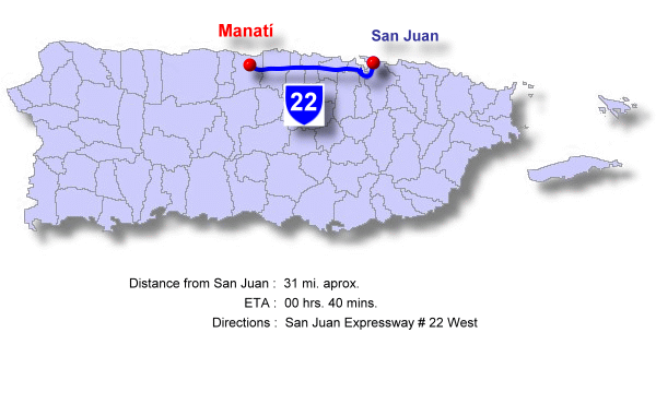
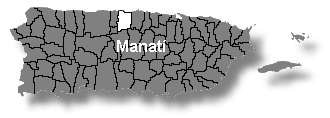
Located on the north coast of Puerto Rico, Manatí borders the Atlantic Ocean to the north, the municipalities of Ciales and Morovis to the south, Vega Baja to the east, and Barceloneta and Florida to the west. Its strategic location has supported urban growth, regional connectivity, and economic development.
From a geographic perspective, Manatí forms part of the Northern Coastal Plain and the karst region, an environment characterized by caves, mogotes (also known as “pepinos”), and sinkholes, along with extensive underground aquifer systems that have been essential to agricultural development and water supply in the region.
The municipality also stands out for its high-value natural beaches, most notably Mar Chiquita and Los Tubos, recognized for their rock formations, wave conditions, and recreational appeal. These coastal areas are central to local identity and regional tourism. Beach-related activities and festivals are held in July, while February features the patron saint festivities honoring Our Lady of Candelaria, the town’s patroness.
Economically, Manatí has consolidated its position as one of Puerto Rico’s principal industrial centers, with a strong presence in the pharmaceutical industry. This is complemented by manufacturing of electrical and electronic equipment, scientific instruments, footwear, and apparel. At the same time, fertile lands and a network of aquifers support agricultural production—particularly pineapples, coconuts, and other minor crops. Commerce, service industries, and regional tourism further complement the local economy, positioning Manatí as a key urban hub in north-central Puerto Rico.
Foundation and History
Manatí was officially founded in 1738 by Don Pedro Menéndez Valdés, becoming the ninth town to receive the blessing of the Spanish Crown in Puerto Rico. Its early development was closely linked to the natural wealth of the valley and the presence of significant water resources.
Before its formal founding, the area was explored by Juan Ponce de León, attracted by fertile lands and by the promise of gold associated with the Manatuabón River. However, strong surf and coastal conditions forced the abandonment of the first settlements in the area, eventually leading to the founding of Caparra, the island’s first permanent Spanish settlement.
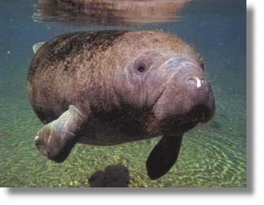
The name Manatí is traditionally associated with the abundance of manatees in the waters near the north coast. Other historical interpretations point to an Indigenous origin, linked to the name of the Manatuabón River used by the Taíno inhabitants of the region. In either case, the name reflects the municipality’s deep relationship with its natural resources and aquatic environment.
During the colonial period, Manatí became established as a region of fertile lands, supplied by springs, underground aquifers, lagoons, and rivers, including the imposing Río Grande de Manatí, one of the longest and most voluminous rivers in Puerto Rico. These conditions fostered agricultural development and the establishment of rural communities that formed the foundation of the town’s growth.
Throughout the nineteenth century and early twentieth century, Manatí experienced notable cultural development, standing out as a center of intellectual, literary, and artistic activity. This cultural flourishing gave rise to the nickname “The Athens of Puerto Rico,” recognizing the municipality’s contributions to the island’s cultural life through literary gatherings, publications, competitions, and other expressions of Puerto Rican thought.
In recognition of its economic, industrial, and urban growth, Manatí was officially elevated to city status in July 1994. From that point forward, it became formally identified as a Metropolitan City, a title that reflects its role as an industrial, commercial, and service hub in northern Puerto Rico. This designation was also reflected in the evolution of its municipal symbols, reaffirming Manatí’s status within Puerto Rico’s contemporary development.
Territorial Organization and Demographic Profile
Manatí is a municipality with a well-defined territorial structure and a demographic profile representative of Puerto Rico’s northern region, combining urban areas, coastal communities, and rural inland zones.
Location:
 The municipality of Manatí is located on the north coast of Puerto Rico, within a strategic region that connects the Atlantic coastline with the island’s mountainous interior.
Manatí borders the Atlantic Ocean to the north, the municipalities of Morovis and Ciales to the south, Florida and Barceloneta to the west, and Vega Baja to the east. This geographic position has been a determining factor in its historical, economic, and urban development.
Its location has allowed Manatí to function as a link between the coastal zone and the interior, facilitating regional commerce, population mobility, and the establishment of major industrial and service sectors in north-central Puerto Rico.
Land Area
- 120.0 square kilometers
- 46.0 square miles
Population
- 40,614 residents (2020 Census)
After several decades of industrial and urban growth, Manatí’s population has remained relatively stable in recent years, reflecting demographic trends similar to those of other municipalities along the island’s northern coast.
Population Density
- 338 inhabitants per square kilometer
- 884 inhabitants per square mile
The highest population concentration is found in the urban core, particularly in the Coto Norte and Coto Sur sectors, as well as in areas near major roadways and industrial zones.
Demonym
- Manatieños
- Atenienses
Nicknames
- Metropolitan City
- The Athens of Puerto Rico
These titles reflect both Manatí’s urban and industrial development and its enduring cultural and intellectual legacy.
Wards: Manati, Puerto Rico
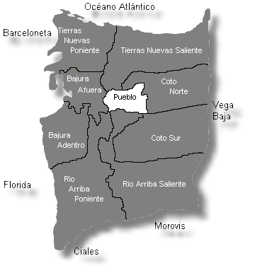
| Census 2020: Population by Wards - Manatí |
Habitant |
| Bajura Adentro | 2,100 |
| Bajura Afuera | 620 |
| Coto Norte | 11,311 |
| Coto Sur | 9,200 |
| Manatí Town | 6,200 |
| Río Arriba Poniente | 1,420 |
| Río Arriba Saliente | 2,600 |
| Tierras Nuevas Poniente | 3,520 |
| Tierras Nuevas Saliente | 7,350 |
| Total | 40,614 |
Información: US Censo 2020
Religious Patron and Traditions
The municipality of Manatí honors Our Lady of Candelaria as its patron saint, a devotion deeply rooted in the town’s history and spiritual life. The figure of the Virgin of Candelaria represents faith, religious identity, and the cultural continuity of generations of Manatí residents.
Patron Saint: Our Lady of Candelaria
Parish: Our Lady of Candelaria Parish
The Our Lady of Candelaria Parish is the municipality’s main religious center and one of the most significant historic buildings in the urban core.
Address: Betances–Padial Street, Manatí, PR 00674
Phone: (787) 854-2013
Year of Parish foundation: 1738
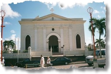
Mass schedule:
- Daily: 6:30 a.m. and 7:00 p.m.
- Saturdays: 6:30 a.m. and 7:00 p.m.
- Sundays: 7:00 a.m., 9:00 a.m., 10:30 a.m., and 7:00 p.m.
The parish serves not only as a place of worship but also as a community gathering point, hosting liturgical, cultural, and social activities throughout the year.
Geography and Natural Environment
Manatí is located on the north coast of Puerto Rico, within the Northern Coastal Plain and an extensive karst region. This geological environment is characterized by the presence of mogotes (also known as “pepinos”), caves, sinkholes, and underground aquifer systems—features that have shaped the landscape, land use, and water availability in the municipality.
Topography and Karst Zone
Manatí’s topography is mostly flat to gently rolling in coastal and valley areas, with karst elevations rising toward the interior. These mogotes and karst formations not only add scenic value but also play a crucial role in aquifer recharge, which is essential for water supply and agricultural development in northern Puerto Rico.
Hydrography
The municipality has water resources of major importance at the island level. The Río Grande de Manatí stands out as one of Puerto Rico’s longest and most voluminous rivers, whose basin has historically been vital for agriculture, human settlement, and local ecosystems. In addition, Laguna Tortuguero—one of the largest natural lagoons in the Caribbean—is recognized for its biodiversity and its ecological role in regulating water systems in northern Puerto Rico.
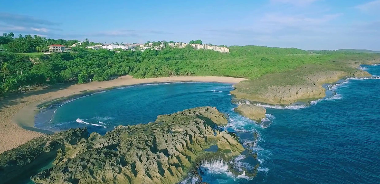
Coastline and Beaches
Manatí is widely recognized for its coastline and high-value natural beaches, particularly Mar Chiquita and Los Tubos.
- Mar Chiquita is distinguished by its semicircular rock formation that creates a natural pool.
- Los Tubos is known for its strong surf, making it a popular spot for surfing and other recreational activities.
These beaches are an essential part of the municipality’s tourism and recreational appeal.
Climate
Manatí has a humid tropical climate, with warm temperatures year-round and a moderating influence from the Atlantic Ocean. Annual rainfall and the presence of extensive aquifers support lush vegetation and allow agricultural, recreational, and tourism activities to continue throughout the year.
Economy and Industries
Manatí’s economy is characterized by its diversification and strategic importance in northern Puerto Rico, combining advanced industry, agriculture, commerce, and services.
Pharmaceutical Industry and Manufacturing
Manatí is one of the country’s leading industrial hubs, with a strong presence in the pharmaceutical industry, which for decades has been a major driver of employment, investment, and technological development. Alongside this sector, manufacturing plants dedicated to electrical and electronic equipment, scientific instruments, footwear, and apparel operate in the municipality, consolidating Manatí as a manufacturing hub of the north.
This industrial base has supported the development of infrastructure, workforce training, and economic linkages with neighboring municipalities.
Agriculture and Local Production
Despite its industrial profile, Manatí maintains a significant agricultural tradition, supported by fertile lands and aquifer systems typical of the karst region. Key crops include pineapple, coconut, and other minor fruits, as well as complementary agricultural activities that remain part of the municipality’s rural landscape.
Agriculture has historically been a core component of the local economy and continues to contribute to food security and employment in rural sectors.
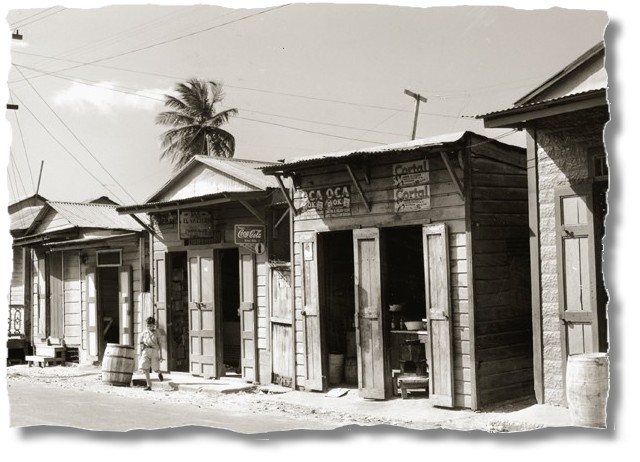
Commerce and Services
Manatí functions as an urban and commercial center for the north-central region, attracting residents from nearby municipalities for shopping, professional services, healthcare, education, and entertainment. Local commerce includes small and medium-sized businesses, as well as larger chains and specialized services that sustain daily economic activity.
Regional Tourism
Tourism in Manatí is primarily supported by its natural and coastal resources, such as Mar Chiquita, Los Tubos, Laguna Tortuguero, and nearby natural reserves. Festivals, cultural activities, and sporting events further generate seasonal economic activity and promote the municipality as a regional destination.
Taken together, the interaction between industry, agriculture, commerce, and tourism positions Manatí as a Metropolitan City with a solid economy and a key role in the development of northern Puerto Rico.
Municipal Government and Services
Manatí operates under an autonomous municipal government, led by a mayor and a municipal legislature elected by popular vote. The local administration is responsible for planning and implementing public policies aimed at residents’ well-being and the municipality’s sustainable development.
Municipal Administration
Manatí’s City Hall serves as the municipality’s administrative center and houses its main government offices. From there, areas such as public works, urban planning, economic development, culture, recreation, and community programs are coordinated.
The municipal government also collaborates with state and federal agencies on infrastructure projects, environmental management, and social services, reflecting Manatí’s strategic importance as an industrial city and regional urban center.
Essential Services
The municipality provides and coordinates essential services, including:
- Maintenance of public roads and municipal infrastructure
- Emergency management and civil protection
- Public safety services, in coordination with the Puerto Rico Police
- Preventive health programs and community services
- Environmental management, particularly in coastal, karst, and protected natural areas
These services are fundamental to meeting the needs of both the resident population and the transient population that comes to the municipality for work, commerce, and tourism.
Infrastructure and Connectivity
Manatí has a well-developed road network that facilitates access to neighboring municipalities and the northern metropolitan area, reinforcing its role as an industrial and commercial hub. Public utility infrastructure—water, electricity, and telecommunications—has been key to sustaining manufacturing activity and urban growth.
Culture, Education, and Community Life
Manatí has maintained an active and diverse cultural life over time, which is why it has historically been recognized as “The Athens of Puerto Rico.” This cultural legacy is reflected in literature, music, theater, the arts, and a strong educational tradition that has shaped the municipality’s identity.
Cultural Life
During the early decades of the 20th century, Manatí stood out as a center of intellectual and artistic activity, attracting poets, writers, musicians, and thinkers who contributed to Puerto Rico’s cultural development. This tradition remains alive through cultural events, artistic performances, community workshops, and festivals that encourage civic participation.
Spaces such as Teatro Taboas, municipal libraries, and cultural centers serve as venues for educational and artistic activities, strengthening access to culture for both residents and visitors.
Education
Manatí has an educational system that includes public and private schools serving elementary, middle, and high school levels. These institutions are an integral part of the municipality’s social development and have played a key role in educating generations of professionals and community leaders.
Manatí’s strategic location also facilitates access to universities and technical institutions in nearby northern and metropolitan municipalities, expanding educational opportunities for its population.
Sports and Recreation
Sports and recreation are important components of community life in Manatí. The municipality offers sports facilities, recreational parks, and multipurpose complexes dedicated to physical activities and community events.
Among the most practiced sports are baseball, basketball, and volleyball, along with family-oriented recreational activities and sports programs organized by the municipality and community organizations.
Community Participation
Community, cultural, and religious organizations play an active role in preserving traditions, organizing local events, and strengthening the sense of belonging. These initiatives help maintain a dynamic community life and reinforce social bonds within the municipality.
Patron Saint Festivals
Manatí’s patron saint festivals are traditionally celebrated in February, in honor of Our Lady of Candelaria. These festivities combine religious acts—such as processions and solemn masses—with cultural, musical, and recreational events that attract both residents and visitors from the northern region.
The celebrations reflect the integration of faith, tradition, and community life and are an essential part of the municipality’s cultural calendar.
Tradition and Popular Devotion
Devotion to the Virgin of Candelaria has historically influenced Manatí’s customs, cultural expressions, and municipal symbols. The traditional bonfires associated with the celebration—represented even on the municipal coat of arms—evoke light, spiritual protection, and the unity of the people.
This religious tradition continues to be a central element of Manatí’s identity and of the transmission of cultural and spiritual values from generation to generation.
Municipal Symbols
The municipal symbols of Manatí reflect its history, cultural identity, and urban development, as well as its recognition as a city.
Flag of Manatí
 The flag of Manatí is composed of three horizontal bands:
- Wide white band
- Wide blue band
- Central red band
These colors are associated with the town’s founder, Don Pedro Menéndez Valdés, and his family coat of arms. The design and colors symbolize Manatí’s historical heritage, civic identity, and institutional continuity.
Coat Of Arms:
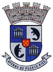 The municipal coat of arms has a quartered design that integrates historical, cultural, and symbolic elements:
- Blue field: a silver Greek temple, a direct reference to the nickname “The Athens of Puerto Rico,” symbolizing the municipality’s cultural and intellectual legacy.
- Silver field: a black manatee, representing the origin of the town’s name and its connection to the natural and marine environment.
- Central escutcheon (red): five golden flames arranged in an X-shape, symbolizing the traditional bonfires of the patron saint festivities in honor of Our Lady of Candelaria.
The coat of arms is crowned by a mural crown, which since 1994 displays five towers, the heraldic distinction of cities and a reflection of Manatí’s status as a Metropolitan City.
Together, the flag and coat of arms summarize Manatí’s historical evolution, cultural development, and contemporary identity within Puerto Rico.
Places of Interest in Manatí
Manatí offers a wide range of historical, cultural, natural, and recreational sites that highlight its regional importance and rich heritage.
Historical and Cultural Heritage
- Our Lady of Candelaria and Saint Matthias the Apostle Parish – The municipality’s main religious temple and one of the most emblematic historic buildings in the urban center.
- Teatro Taboas – A venue for performing arts, cultural activities, and community events; a cornerstone of “The Athens of Puerto Rico” legacy.
- Francisco Álvarez Marrero Municipal Library – Center for access to knowledge, literature, and local history, named after the Manatí-born poet and journalist.
- Hall of Poets – Cultural space honoring the municipality’s literary tradition and intellectual figures.
- Plaza of History – Urban area dedicated to Manatí’s historical memory and cultural development.
- Old Market Plaza – Historic structure tied to the municipality’s traditional commercial life.
- Manatí City Hall – Seat of municipal government and a central landmark in the urban core.
- Old Municipal Cemetery – Site of historical and heritage value preserving part of the town’s collective memory.
- Central La Monserrate – Former sugar mill representing the region’s industrial and agricultural history (historic structure).
Natural and Religious Spaces
- Hacienda La Esperanza Nature Reserve – Protected area of high ecological, historical, and agricultural value with trails and interpretive spaces.
- Laguna Tortuguero Nature Reserve – One of the largest natural lagoons in the Caribbean, noted for its biodiversity and ecological importance.
- Río Encantado Protected Natural Area – Scenic and ecologically significant area connected to the municipality’s river system.
- Sanctuary of Christ of the Miracles and Monte Calvario – Site of pilgrimage and religious devotion with spiritual and cultural value.
Recreation and Sports
- Acrópolis Sports Complex – Facility dedicated to sports and recreational activities.
- Pedro Román Meléndez Municipal Stadium – Main stadium hosting sports and community events.
- Los Tubos Recreational Area and Beach – Coastal space combining recreation, sports, and direct contact with the sea.
Urban Spaces and Walkways
- The Athens Promenade (El Paseo de la Atenas) – Pedestrian and cultural corridor honoring Manatí’s intellectual legacy and connecting key areas of the urban center.
Beaches of Manatí
Manatí’s coastline features several beaches of high natural and recreational value, appreciated by residents and visitors alike:
- Mar Chiquita Beach – One of the most iconic beaches on Puerto Rico’s north coast, known for its semicircular rock formation that creates a natural pool.
- La Poza de las Mujeres Beach – A quieter, community-oriented beach used mainly for family recreation.
- Los Tubos Beach – Famous for strong waves; a popular destination for surfing and water sports.
- Tortuguero Beach – Linked to the Laguna Tortuguero ecosystem and part of a high-value ecological coastal zone.
- La Esperanza Beach – A more natural, less developed beach used for outdoor recreation, especially by local residents.
These beaches are essential to Manatí’s coastal identity and enhance its appeal as a recreational and tourism destination on the island’s north coast.
Events and Festivities
Throughout the year, Manatí hosts a variety of cultural, religious, and recreational events that strengthen local identity and attract visitors from across the northern region:
- Patron Saint Festivities of Our Lady of Candelaria (February) – The municipality’s most important religious and cultural celebration, featuring masses, processions, music, crafts, and family activities.
- Mar Chiquita Festival (July) – Beach-focused event highlighting one of Manatí’s main natural attractions.
- Los Tubos Festival (June/July) – Centered on coastal culture and surfing; promotes regional tourism.
- Christmas Festival (December) – Cultural and community activities marking the start of the holiday season.
These events reflect Manatí’s cultural and natural diversity, integrating tradition, recreation, and community life.
Notable Figures
Manatí has been the birthplace of influential individuals who contributed to Puerto Rico’s cultural, artistic, political, and social development:
- José Miguel Class – Known as “El Gallito de Manatí,” a popular singer with national and international reach.
- Francisco Álvarez Marrero – Poet and journalist; founder of La Voz del Norte.
- Epifanio Fernández Vanga – Essayist and advocate for Spanish-language education; author of El idioma de Puerto Rico.
- Néstor Rodríguez Escudero – Short story writer and essayist; author of Jaicoa, cuentos y leyendas.
- Miguelito Miranda – Renowned trumpeter.
- Juan Ramón Ramos Vélez – Attorney and politician.
- Clemente Ramírez de Arellano – Poet and politician.
Together, these figures embody the intellectual and cultural legacy that gave rise to Manatí’s enduring nickname, “The Athens of Puerto Rico.”
Public Schools sorted by educational levels.
Arecibo Region
Manatí District
| Name | Level | Telephone | Address |
| Elementary | |||
| ANTONIO VÉLEZ ALVARADO | K-6 | (787) 854-4160 | PO Box 30160 Suite 282, P.R. 00674-0000 |
| AUGUSTO COHEN | K-5 | (787) 884-6519 | PO Box 1014, P.R. 00674-0000 |
| CLEMENTE RAMÍREZ DE ARELLANO | K-6 | (787) 884-3031 | Suite 339, P.R. 00674-0000 |
| CRUZ ROSA RIVAS | K-6 | (787) 854-4900 | PO Box 506, P.R. 00674-0000 |
| EVARISTO CAMACHO | K-6 | (787) 854-6315 | PO Box 30160, P.R. 00674-0000 |
| FÉLIX CÓRDOVA DÁVILA | K-6 | (787) 854-4255 | PO Box 30160 Suite 173, P.R. 00674-0000 |
| FRANCISCO MENÉNDEZ BALBAÑE | K-6 | (787) 854-3063 | PMB 106, P.R. 00674-0000 |
| JOSÉ DE DIEGO | PK-6 | (787) 854-2272 | PO Box 174, P.R. 00674-0000 |
| JOSÉ MELÉNDEZ AYALA I | K-6 | (787) 854-6788 | PO Box 506, P.R. 00674-0000 |
| JOSEFA RIVERA MIRANDA | K-6 | (787) 854-7227 | PO Box 506, P.R. 00674-0000 |
| JUAN A. SÁNCHEZ DÁVILA | K-6 | (787) 854-7747 | PO Box 1397, P.R. 00674-0000 |
| MICAELA ESCUDERO | K-6 | (787) 889-3106 | PO Box 3081, P.R. 00674-0000 |
| TEODOMIRO TABOAS | K-6 | (787) 854-2255 | PO Box 506, P.R. 00674-0000 |
| Intermediate | |||
| JESÚS T PIÑERO | 7-9 | (787) 854-2259 | PO Box 3158, P.R. 00674-0000 |
| NUEVA JUAN S. MARCHAND | 7-9 | (787) 854-4541 | PO Box 506, P.R. 00674-0506 |
| Institutional | |||
| INSTITUTO TECN. RECINTO DE MANATÍ | 13-14 | (787) 854-2050 715 | PO Box 506, P.R. 00674-0000 |
| Secondary | |||
| SU FEDERICO FREYTES RODRÍGUEZ | K-9 | (787) 854-9672 | PO Box 1844, P.R. 00674-0000 |
| High School | |||
| FERNANDO CALLEJO | 10-12 | (787) 854-2629 | PO Box 3355, P.R. 00674-3355 |
| JOSÉ A. MONTAÑEZ GENARO (VOC. AREA) | 10-12 | (787) 854-2250 | PO Box 1091, P.R. 00674-0000 |
| PETRA CORRETJER DE O'NEILL | 10-12 | (787) 854-6601 | PO Box 30160 Suite 335, P.R. 00674-0000 |
Hymn:
Atenas de Borinquen - By Wilfredo Pagán
Que bonito ver la grandezas
de la tierra en que nací.
Ver su florrecer y sus playas
como brillan al dormir.
Orgulloso estoy de mi pueblo
y precioso Manati.
Que grtandioso es conocer
cómos se ha llamdo así.
En la Atena de Borinquen
en su cuna meció
todos esos próceres que allí cultivaron
todos los talentos que un pueblo nació,
y a su nombre proclamó.
Es la Atenas de Borinquen
de gracias y esplendor
de hermosas paisajes que serán recordados
si en tus bellas tierras no llegase a morir
te prometo que nunca serán olvidados.
En mi corazón llevar grabado
el nombre de Manati:
y será mi honor
porque ha sido la razón de mi existir.